The masterplan embraces the countryside and enhances natural habitats, with parks, a riverine corridor, and SANG offering peaceful outdoor spaces for residents.
Priors FarmSouth Wokingham SDL Extension
UK
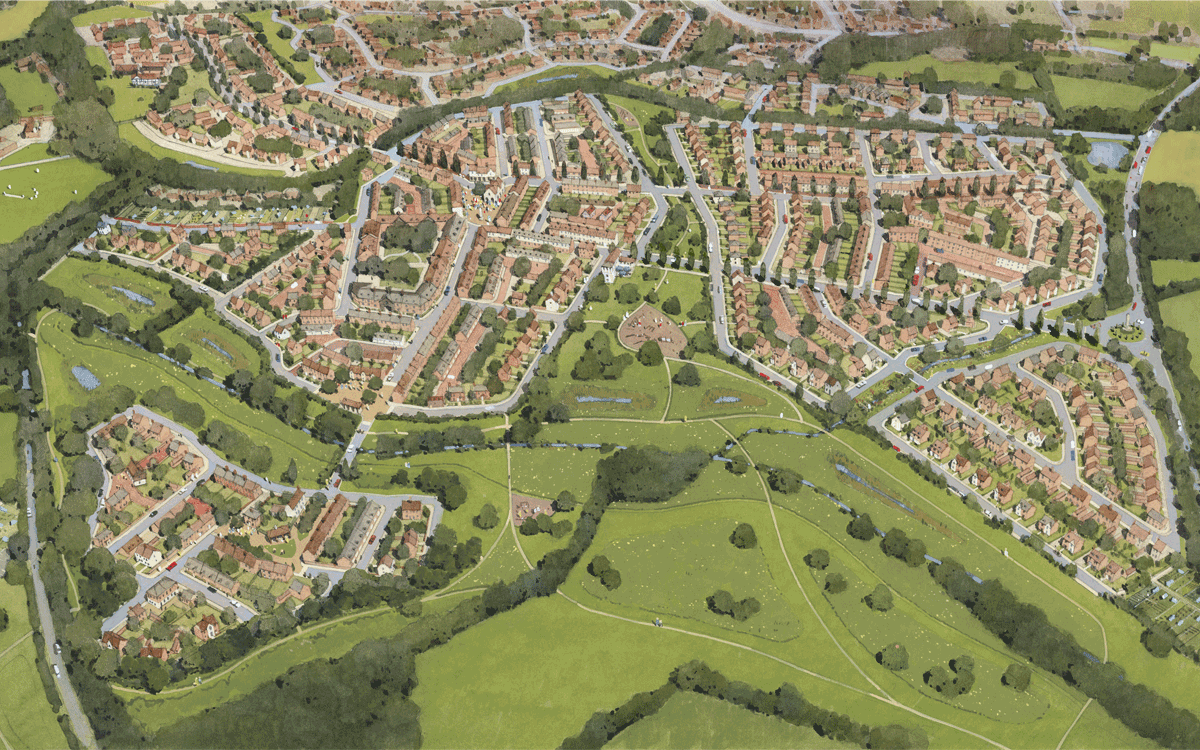
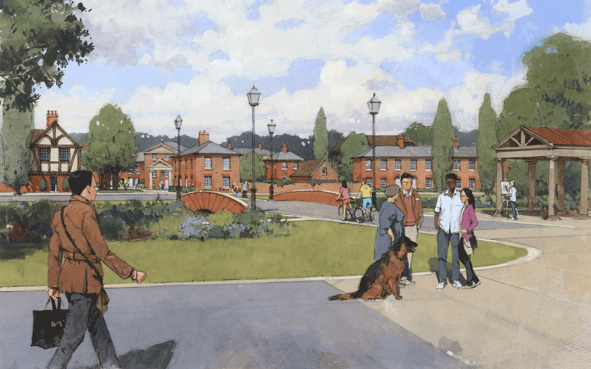
The new residential and mixed-use masterplan at Priors Farm forms part of the Wokingham SDL Extension and consists of a local centre providing mixed and community uses for a series of local neighbourhoods each with its own square. This market square for the community is no more than a ten minutes’ walk away from the centre of each of the surrounding neighbourhoods. Buildings are arranged along a network of streets, lanes and squares in the traditional manner to create a pleasant and varied environment with a legible hierarchy for people to walk and find their way around. There are avenues and green open spaces and the masterplan takes advantage of being on the edge of Wokingham to incorporate a park and draw in the countryside.
It provides the infrastructure for people of all ages so that a new community can develop and thrive. A detailed code has been developed to define all public spaces, landmarks and the architecture of the houses reflecting the character of historic old Wokingham. This has a very specific form derived from the silk trade which was once very prominent in the area. An architectural code is used to define the development pattern to introduce architectural variety by mimicking that of a traditional town that has grown incrementally over time. This makes it feel a natural part of the locality which conforms with the National Model Design Code and criteria set out by the Government Office for Place. In addition to this, an allocation of houses capable of accommodating the growing requirement for people to work from home will make for a more lively and active place.
The masterplan provides generous green open space including a park, SANG and incorporates an existing watercourse into a green corridor that provides sustainable drainage (Suds) provision for the whole development. It has is well connected, with a bus route, providing sustainable transport fitting into a wider network of active travel routes and encourages different modes of transport linking to existing and neighbouring developments. It has been designed to be a walkable community encouraging active travel in an environment that will contribute to the wellbeing and enjoyment of the inhabitants.

Priors Farm at Wokingham offers a beautifully planned development with walkable streets, green spaces, and community facilities, designed for people to thrive and connect.
Priors FarmSouth Wokingham SDL Extension
UK
The new residential and mixed-use masterplan at Priors Farm forms part of the Wokingham SDL Extension and consists of a local centre providing mixed and community uses for a series of local neighbourhoods each with its own square. This market square for the community is no more than a ten minutes’ walk away from the centre of each of the surrounding neighbourhoods. Buildings are arranged along a network of streets, lanes and squares in the traditional manner to create a pleasant and varied environment with a legible hierarchy for people to walk and find their way around. There are avenues and green open spaces and the masterplan takes advantage of being on the edge of Wokingham to incorporate a park and draw in the countryside.
It provides the infrastructure for people of all ages so that a new community can develop and thrive. A detailed code has been developed to define all public spaces, landmarks and the architecture of the houses reflecting the character of historic old Wokingham. This has a very specific form derived from the silk trade which was once very prominent in the area. An architectural code is used to define the development pattern to introduce architectural variety by mimicking that of a traditional town that has grown incrementally over time. This makes it feel a natural part of the locality which conforms with the National Model Design Code and criteria set out by the Government Office for Place. In addition to this, an allocation of houses capable of accommodating the growing requirement for people to work from home will make for a more lively and active place.
The masterplan provides generous green open space including a park, SANG and incorporates an existing watercourse into a green corridor that provides sustainable drainage (Suds) provision for the whole development. It has is well connected, with a bus route, providing sustainable transport fitting into a wider network of active travel routes and encourages different modes of transport linking to existing and neighbouring developments. It has been designed to be a walkable community encouraging active travel in an environment that will contribute to the wellbeing and enjoyment of the inhabitants.
With a mix of residential, commercial facilities, and flexible spaces for remote work, this development provides everything needed for a lively, modern community.
Priors FarmSouth Wokingham SDL Extension
UK
The new residential and mixed-use masterplan at Priors Farm forms part of the Wokingham SDL Extension and consists of a local centre providing mixed and community uses for a series of local neighbourhoods each with its own square. This market square for the community is no more than a ten minutes’ walk away from the centre of each of the surrounding neighbourhoods. Buildings are arranged along a network of streets, lanes and squares in the traditional manner to create a pleasant and varied environment with a legible hierarchy for people to walk and find their way around. There are avenues and green open spaces and the masterplan takes advantage of being on the edge of Wokingham to incorporate a park and draw in the countryside.
It provides the infrastructure for people of all ages so that a new community can develop and thrive. A detailed code has been developed to define all public spaces, landmarks and the architecture of the houses reflecting the character of historic old Wokingham. This has a very specific form derived from the silk trade which was once very prominent in the area. An architectural code is used to define the development pattern to introduce architectural variety by mimicking that of a traditional town that has grown incrementally over time. This makes it feel a natural part of the locality which conforms with the National Model Design Code and criteria set out by the Government Office for Place. In addition to this, an allocation of houses capable of accommodating the growing requirement for people to work from home will make for a more lively and active place.
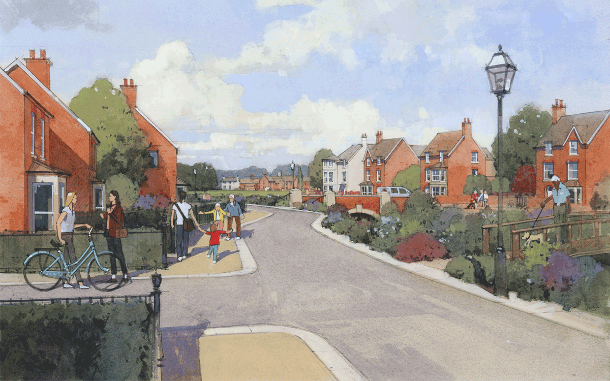
The masterplan provides generous green open space including a park, SANG and incorporates an existing watercourse into a green corridor that provides sustainable drainage (Suds) provision for the whole development. It has is well connected, with a bus route, providing sustainable transport fitting into a wider network of active travel routes and encourages different modes of transport linking to existing and neighbouring developments. It has been designed to be a walkable community encouraging active travel in an environment that will contribute to the wellbeing and enjoyment of the inhabitants.

Promoting active travel and wellbeing, the development is designed to be walkable, connecting homes with community spaces, cycle paths, and footways for easy, sustainable living.
Priors FarmSouth Wokingham SDL Extension
UK
The new residential and mixed-use masterplan at Priors Farm forms part of the Wokingham SDL Extension and consists of a local centre providing mixed and community uses for a series of local neighbourhoods each with its own square. This market square for the community is no more than a ten minutes’ walk away from the centre of each of the surrounding neighbourhoods. Buildings are arranged along a network of streets, lanes and squares in the traditional manner to create a pleasant and varied environment with a legible hierarchy for people to walk and find their way around. There are avenues and green open spaces and the masterplan takes advantage of being on the edge of Wokingham to incorporate a park and draw in the countryside.
It provides the infrastructure for people of all ages so that a new community can develop and thrive. A detailed code has been developed to define all public spaces, landmarks and the architecture of the houses reflecting the character of historic old Wokingham. This has a very specific form derived from the silk trade which was once very prominent in the area. An architectural code is used to define the development pattern to introduce architectural variety by mimicking that of a traditional town that has grown incrementally over time. This makes it feel a natural part of the locality which conforms with the National Model Design Code and criteria set out by the Government Office for Place. In addition to this, an allocation of houses capable of accommodating the growing requirement for people to work from home will make for a more lively and active place.
The masterplan provides generous green open space including a park, SANG and incorporates an existing watercourse into a green corridor that provides sustainable drainage (Suds) provision for the whole development. It has is well connected, with a bus route, providing sustainable transport fitting into a wider network of active travel routes and encourages different modes of transport linking to existing and neighbouring developments. It has been designed to be a walkable community encouraging active travel in an environment that will contribute to the wellbeing and enjoyment of the inhabitants.
Rooted in Wokingham’s rich heritage, our masterplan celebrates local identity, drawing inspiration from the town’s classical legacy and surrounding nature.
Priors FarmSouth Wokingham SDL Extension
UK
The new residential and mixed-use masterplan at Priors Farm forms part of the Wokingham SDL Extension and consists of a local centre providing mixed and community uses for a series of local neighbourhoods each with its own square. This market square for the community is no more than a ten minutes’ walk away from the centre of each of the surrounding neighbourhoods. Buildings are arranged along a network of streets, lanes and squares in the traditional manner to create a pleasant and varied environment with a legible hierarchy for people to walk and find their way around. There are avenues and green open spaces and the masterplan takes advantage of being on the edge of Wokingham to incorporate a park and draw in the countryside.
It provides the infrastructure for people of all ages so that a new community can develop and thrive. A detailed code has been developed to define all public spaces, landmarks and the architecture of the houses reflecting the character of historic old Wokingham. This has a very specific form derived from the silk trade which was once very prominent in the area. An architectural code is used to define the development pattern to introduce architectural variety by mimicking that of a traditional town that has grown incrementally over time. This makes it feel a natural part of the locality which conforms with the National Model Design Code and criteria set out by the Government Office for Place. In addition to this, an allocation of houses capable of accommodating the growing requirement for people to work from home will make for a more lively and active place.
The masterplan provides generous green open space including a park, SANG and incorporates an existing watercourse into a green corridor that provides sustainable drainage (Suds) provision for the whole development. It has is well connected, with a bus route, providing sustainable transport fitting into a wider network of active travel routes and encourages different modes of transport linking to existing and neighbouring developments. It has been designed to be a walkable community encouraging active travel in an environment that will contribute to the wellbeing and enjoyment of the inhabitants.